How does LiDAR technology work?
How does LiDAR technology work?
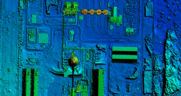
Have you ever wondered how does LiDAR technology work? Aerial LiDAR surveys involve using specialised remote sensing technology to obtain high-resolution topographic data from the air. LiDAR stands for “Light Detection and Ranging” and works by sending out pulses of laser light that bounce off the earth’s surface and return to the sensor. By measuring the time it takes for the laser to bounce back, the sensor can determine the distance between the sensor and the ground.
During an aerial LiDAR survey, an aircraft or drone equipped with a LiDAR sensor flies over the survey area, typically at a height of several hundred metres. The sensor sends out thousands of laser pulses per second, and the reflected signals are recorded by the sensor’s receiver. The data collected is then processed using specialised software to create a highly detailed 3D map of the area.
What is LiDAR technology used for?
Aerial LiDAR surveys are commonly used for a wide range of applications, including land surveying, urban planning, forestry, agriculture, and environmental monitoring. The high-resolution data obtained from LiDAR surveys can provide detailed information on the topography of an area, including elevation, slope, and surface features. This information can be used to create detailed maps and models that can be used for a variety of purposes, such as planning new construction projects or managing natural resources.
Aerial LiDAR (Light Detection and Ranging) surveys involve the use of a laser scanner mounted on an aircraft or drone to create highly accurate 3D models of the terrain below. The laser scanner emits pulses of light that bounce off the ground and return to the sensor, allowing it to measure the precise distance between the aircraft and the ground. By scanning the terrain below from multiple angles and combining the data, a highly detailed 3D model of the terrain can be created.
Aerial LiDAR surveys are often used for mapping, land surveying, forestry management, and environmental monitoring. They can be used to create digital elevation models, contour maps, and 3D models of structures and buildings.
What are the advantages of LiDAR surveys?
One advantage of LiDAR surveys over traditional surveying methods is that they can cover large areas quickly and accurately. They can also capture data in areas that may be difficult or unsafe to access on foot. Additionally, LiDAR data can be used for a variety of applications beyond the initial survey, such as analysing terrain for flood risk, assessing vegetation cover for ecological studies, and monitoring changes in land use over time.
What steps are involved in a LiDAR survey?
Lidar survey processing involves several steps to turn the raw data collected during an aerial LiDAR survey into usable 3D models or maps. Here are the basic steps involved in LiDAR survey processing:
- Data acquisition: This is the initial step, where LiDAR data is collected from the aircraft. The collected data is in the form of point clouds, which are essentially 3D coordinates of the laser returns.
- Quality control: Once the data is collected, quality control measures are applied to ensure that the data is accurate and complete. This can include removing outliers or noise from the point cloud data.
- Data classification: In this step, the point cloud data is classified into different categories such as ground, vegetation, buildings, and water bodies. This classification helps in separating the different elements in the point cloud data and improves the accuracy of the final output.
- Surface generation: After classification, the point cloud data is used to generate surfaces such as digital elevation models (DEMs) and digital surface models (DSMs). DEMs show the elevation of the ground surface, while DSMs show the height of all objects on the ground surface, including buildings and vegetation.
- Feature extraction: This step involves extracting features from the point cloud data, such as building footprints, tree heights, and vegetation density. This information can be used for various applications such as urban planning, forestry management, and environmental monitoring.
- Output generation: Finally, the processed data is used to generate the desired output such as maps, models, or reports, which can be used for a variety of purposes.
LiDAR survey processing requires specialised software and expertise in data processing and analysis.
- Point cloud to CAD conversion: After processing, the point cloud data is converted into a CAD format using specialised software. The software typically provides tools to select and isolate specific elements of the point cloud data and convert them into 3D CAD objects such as walls, roofs, and floors.
- Modelling and detailing: Once the CAD objects are created, they can be further modelled and detailed using CAD software. This involves adding texture, colours, and other details to the model, and creating 2D drawings with dimensions and annotations.
- Verification: Finally, the CAD drawings are verified and reviewed to ensure accuracy and completeness. The drawings can then be used for a variety of purposes, such as design, planning, and construction.
Creating CAD drawings from LiDAR data requires specialised software and expertise in CAD modelling and LiDAR data processing. It is important to ensure the accuracy of the data and the resulting CAD drawings, as they are often used for critical design and construction purposes.
Angell Surveys is a professionally qualified firm and members of the Royal Institution of Chartered Surveyors. This is the Gold Standard in the surveying industry. The Royal Institution of Chartered Surveyors (RICS) is a professional organisation for surveyors, founded in London in 1868.
RICS promotes and enforces the highest international standards in the valuation, management, development, and use of land, real estate, construction, and infrastructure. It has over 134,000 members globally, working in various fields including property, land, construction, and infrastructure.
Contact us today for more information on our LiDAR drone surveys, or for more information on other services visit our homepage.