Reality Capture
Reality Capture
Reality Capture is advanced photogrammetry software designed to seamlessly create 3D models from unordered photographs or laser scans. Its widespread applications include cultural heritage preservation, full-body scanning, gaming, surveying, mapping, visual effects, and virtual reality.
Reality Capture offers unmatched detail in photo-to-point cloud creation and laser scanning, catering to projects of any size. Its precise mapping ensures intelligent survey outputs that are export-ready, eliminating the need for costly rework.
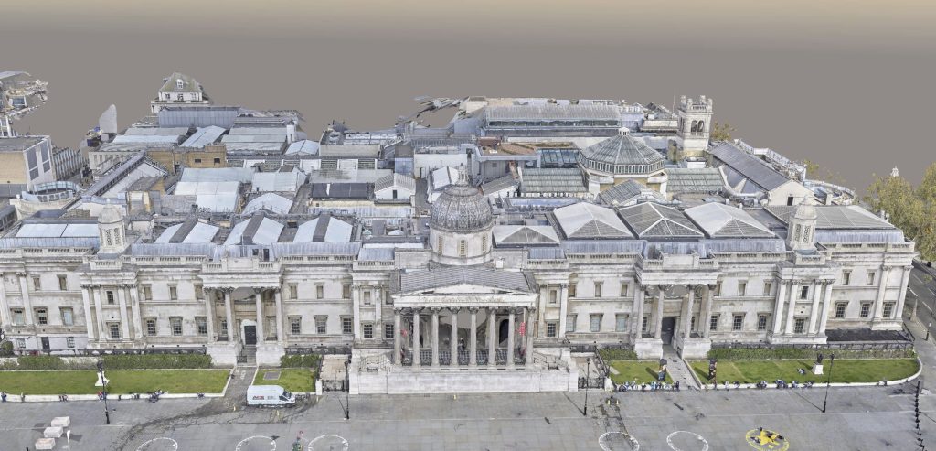
At Angell Surveys we capture the highest resolution aerial data using a PhaseOne 100MP camera, mounted on a drone. This allows us to produce accurate three-dimensional digital twin models with Bentley ContextCapture.
The PhaseOne 100MP system is an exceptional camera. With its full 100MP image resolution and extended 60-minute exposure time, paired with a CMOS sensor boasting low noise and wide dynamic range, the resulting images are nothing short of breathtaking. The lens is specially built to fully complement the 100MP capabilities, ensuring every detail is captured with unparalleled clarity and precision.
Bentley ContextCapture is cutting-edge software that empowers you to create spatially classified and engineering-ready reality meshes at your desired precision and scale, even for vast urban areas. This offers highly accurate and detailed reality meshes for advanced spatial analysis, engineering, and infrastructure planning.
We combine processed aerial data with ground-based laser scans and produce a single model from which various deliverables are produced, including CAD drawings, ortho-facades and 3D solid models.
Angell Surveys excels in drone aerial reality capture. Our approach ensures better data input leads to superior outputs, empowering our clients with accurate and detailed information for efficient asset management and infrastructure planning.
Trust Angell Surveys for cutting-edge technology and expertise in reality capture services, contact us to find out more.