Expert Survey Solutions that deliver.
Expert Survey Solutions that deliver.
A mining survey is the process of measuring, mapping and monitoring mine sites to support safe and efficient operations. It provides accurate information about the land, underground workings and resources so you can plan, design and manage mining projects with confidence. Without this data, it would be difficult to ensure safety, control costs, or maximise […]
A mining survey is the process of measuring, mapping and monitoring mine sites to support safe and efficient operations.
It provides accurate information about the land, underground workings and resources so you can plan, design and manage mining projects with confidence. Without this data, it would be difficult to ensure safety, control costs, or maximise productivity.
Mining surveys help identify potential hazards, define boundaries and guide the placement of infrastructure both above and below ground. By combining modern tools like drones, laser scanning and LiDAR with traditional techniques, surveys give you a detailed picture of the site that supports every stage of the mining process.
Here, we’ll take you through everything you need to know about mining surveys and why they’re an essential element of every mining project.
Mining surveying provides the measurements and data needed to design safe mine workings, calculate mineral reserves and meet strict legal and environmental standards. It combines engineering, geology and regulation to reduce risks such as ground instability, subsidence and land contamination while supporting efficient extraction and land management.
Mining surveying is the process of measuring, recording and analysing the physical conditions of land and underground workings. You use it to define the ground shape, locate ore bodies and assess both coal seams and non-coal deposits.
A mining survey also supports ground investigation, geotechnical stability checks and environmental assessments. These tasks are vital for preventing hazards such as subsidence or collapse.
Surveying applies to every stage of the mining industry. From mineral exploration to mine closure, you rely on accurate data to inform mining engineering, safety planning and land reclamation.
The scope also includes preparing detailed mining reports, maintaining underground mining records and reviewing historic mine plans. These records help you understand legacy risks like abandoned shafts or mine entries.
The main objective of mining surveying is to provide reliable data for safe and efficient mining operations. You use surveys to design excavation layouts, calculate mineral reserve volumes and plan ventilation or drainage systems.
Surveying also plays a role in identifying mining hazards. By tracking ground movement and stability, you can reduce the risk of mining subsidence and protect both nearby structures and your workers.
Applications extend to environmental risk assessments. For example, land contamination assessments and property inspections often require survey data to confirm whether past mining has left pollutants or unstable ground.
Surveys also support economic decisions. Mineral reserve calculations allow you to estimate profitability, while accurate boundary surveys prevent disputes over mineral rights. In coal mining, a coal mining risk assessment may be required by a local planning authority before development.
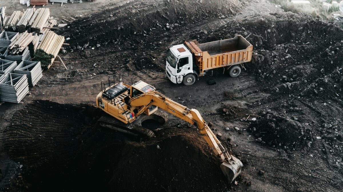
Mining surveys fall into two main categories: surface and underground. Surface surveys measure terrain, access routes and land features above ground. These are essential for planning infrastructure, transport links and land reclamation.
Underground surveys focus on mine shafts, tunnels, and coal seams. They help you monitor ground stability, map mine plans and update non-coal mine records. Underground surveying is also key for detecting voids that could cause future collapse.
Both types often use modern tools such as laser scanning, UAVs and LiDAR. These methods improve accuracy and reduce the need for intrusive site investigations. However, in complex geology, you may still need physical ground investigation to confirm geotechnical stability.
The combination of surface and underground data allows you to create a complete model of the mining area. This supports both engineering design and compliance with reporting requirements.
Mining surveys must comply with a range of UK laws and regulations. The Mining Remediation Authority (previously the Coal Authority) oversees coal mining reports, mine entry data and coal mining risk assessments. Local planning authorities often require these before granting building permission.
Several acts govern safety and reporting. These include the Coal Industry Act 1994, the Coal Mines Regulation Act, the Mine and Quarries Act 1954 and the historic Inspection of Coal Mines Act 1850. Each sets standards for record-keeping and health and safety.
You must also consider the Health and Safety Executive, which enforces workplace regulations. Accurate surveys help you demonstrate compliance and reduce liability.
By meeting these legal requirements, you reduce environmental risk, protect properties and employees and ensure that mining or redevelopment projects proceed without regulatory delays.
Mining surveys rely on a mix of established instruments and modern geospatial technologies. You use them to measure underground workings, surface features and surrounding infrastructure with accuracy that supports safety, planning and compliance. The data collected ranges from boundary lines to 3D terrain models, helping you make informed operational decisions.
Surveys often used to begin with total stations, but you can now deploy UAVs (drones) equipped with high-resolution cameras, RTK modules and thermal cameras to capture detailed imagery without entering dangerous zones. Many systems include real-time terrain following and omnidirectional vision systems to maintain stability in rugged landscapes.
Drone surveys allow you to collect orthomosaic data and orthorectified georeferenced imagery for mapping pits, waste tips and haul roads. Many modern drone models allow you to extend range and maintain connectivity in remote sites.
For larger areas, aerial LiDAR surveys from helicopters or fixed-wing aircrafts capture millions of points per second, producing dense point clouds. This method is especially effective for monitoring slope stability, perimeter monitoring and tracking tree cover or coastal vulnerability near mining operations.
Satellite imagery and other remote sensing tools add another layer of geospatial data. They help you assess flood risk, gas emissions and land-use changes at a regional scale.
Drone surveys help to improve the safety of this essential step in mining projects. By removing the need for humans to inspect potentially dangerous or hazardous mining sites, they protect staff. They’re also more cost-effective than traditional methods, thanks to their efficiency and reduced need for personnel.
Once you capture the raw data, you process it using specialised software. You align images with ground control points to eliminate distortions and ensure survey-grade accuracy.
Drone flights typically generate gigabytes of photos, which you stitch into orthomosaic maps or digital elevation models. LiDAR outputs are converted into point clouds that form the basis for 3D model outputs.
Metadata standards such as DCAT feeds support sharing of survey results across platforms. You can connect with geospatial resources from organisations like the Ordnance Survey or the Geological Society to validate your findings.
Your final deliverables often include a set of maps and models tailored to project needs. Interactive maps allow you to perform spatial searches for infrastructure, highway rail access or underground assets.
Digital terrain models and 3D visualisations help you plan excavation design, ventilation and drainage. Slope stability assessments highlight areas prone to failure, while flood and coastal vulnerability maps guide environmental planning.
Survey results also support regulatory compliance. You can document property boundaries, evaluate mine abandonment plans and provide asset information for investors.
With orthorectified imagery, you maintain a permanent record of surface conditions. Combined with point cloud datasets, you gain accurate measurements of surface features, borehole locations and stockpile volumes that directly influence operational efficiency and safety.
Mining surveys involve precise measurement, advanced technology and strict safety practices. They also play an important role in planning, compliance and reducing environmental risks.
You use detailed measurements of surface and underground areas to create accurate maps. Techniques such as 3D modelling and terrain mapping help identify ore bodies and surrounding features. This data allows you to plan excavation and infrastructure with greater accuracy.
You can apply tools such as laser scanning, drones, LiDAR and mobile mapping vehicles. These technologies speed up data collection while improving accuracy and safety. For example, laser scanning and UAV surveys are widely used to capture high-resolution data in both open-pit and underground sites.
You rely on mining surveyors from exploration through to closure. They map mineral deposits, set boundaries and monitor excavation progress. They also ensure that tunnels, shafts and surface infrastructure are positioned correctly throughout the project.
You must assess ground stability, ventilation and access routes before entering a site. Modern methods like drone surveys reduce the need for surveyors to work near hazardous areas. Accurate mapping also helps design support systems to reduce the risk of cave-ins.
You can use survey data to evaluate land use, water management, and waste storage areas. Mapping helps identify potential effects on surrounding ecosystems. This information is often required to demonstrate compliance with environmental regulations.
You must follow national mining and land laws that define boundary placement and mineral rights. Inaccurate boundary surveys can lead to disputes or financial loss. Regulations also require you to document environmental and safety standards as part of the permitting process.
Trust Angell Surveys for cutting-edge technology, expertise and timely delivery when it matters.