Expert Survey Solutions that deliver.
Expert Survey Solutions that deliver.

Road corridor surveys map and analyse long, narrow areas such as roads, railways and pipelines. These surveys help you plan, design and maintain transport and utility networks efficiently. These surveys give you precise data about terrain, structures and boundaries, helping you make accurate decisions during every stage of a project. Here, we’ll cover the core […]
Road corridor surveys map and analyse long, narrow areas such as roads, railways and pipelines. These surveys help you plan, design and maintain transport and utility networks efficiently.
These surveys give you precise data about terrain, structures and boundaries, helping you make accurate decisions during every stage of a project.
Here, we’ll cover the core principles behind road corridor surveys and how modern tools like precision drone mapping enhance accuracy and efficiency. We’ll also show you how this approach helps you meet project requirements while reducing risk and cost.
A road corridor survey gives engineers, planners and surveyors the accurate measurements and spatial data needed to plan and design safe, durable and efficient transport routes. It uses both traditional field methods and advanced digital systems to assess terrain, define corridor boundaries and support informed route selection.
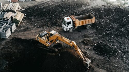
A road corridor survey measures and maps a strip of land intended for a highway or other transport route. It focuses on capturing terrain, existing road networks and structural or environmental constraints within a defined corridor width.
The process often begins with a corridor land survey, which establishes the physical and legal boundaries of the route. High-resolution topographical surveys then record ground elevations, utilities, drainage paths and structures. These survey outcomes inform road corridor design, ensuring alignment and grading are accurate from the earliest planning stages.
Modern corridor surveys typically develop a digital terrain model based on ground data and aerial inputs. This model helps visualise surface features and supports road mapping surveys. It also supports the generation of elevation contours, slope analysis and earthwork volume estimates.
Corridor surveys are most often used during the feasibility, design, and rehabilitation stages of transport projects. Agencies use them to compare route alternatives, estimate land acquisition needs and plan survey control networks before design begins.
Typical stakeholders include transport departments, engineering consultancies and construction contractors. Environmental specialists and local authorities may also take part when corridor alignment crosses sensitive sites or populated areas. Corridor studies help balance safety, cost and public accessibility during planning.
Utility companies rely on accurate survey data to locate underground lines, while planning authorities review alignment and gradient data for regulatory compliance. Stakeholder coordination is essential when updating road corridors within urban environments or expanding highway networks into new regions.
To meet strict survey requirements, you’ll normally combine ground control with remote sensing. A control network ensures positional accuracy by establishing reference points with known coordinates. GNSS, total stations and laser scanners capture horizontal and vertical positions relative to a geoid model and local scale factor.
Drones and mobile mapping vehicles conduct corridor scans over long distances. They collect imagery, LiDAR data and elevation readings faster than conventional crews. These inputs are processed in mapping software to create digital terrain models that support road corridor creation methods.
Using integrated sensors reduces time spent in the field and supports precise road design data outputs. You can then overlay environmental maps, land ownership data and existing road features to produce reliable alignment options.
Road corridor surveys offer improved accuracy, efficiency and safety compared to earlier manual techniques. Automated data capture allows you to cover large areas with fewer site visits, reducing travel time and disruption to live traffic.
A key advantage lies in the speed of processing. Drone-collected imagery and LiDAR data can be converted into usable survey data within days. This rapid turnaround supports the flexible decision-making required for modern road design.
Digital tools also make visual checks easier. In a single corridor scan, you can detect obstacles, drainage features and vegetation density without revisiting the site. Each dataset aligns with the project’s survey control network, maintaining high positional accuracy from start to finish.
This level of detail enables safer, data-driven design choices that improve both project delivery and infrastructure performance.
You can use drones to capture accurate, high‑resolution data for road corridor surveys while improving efficiency and safety. With the right sensors and flight planning tools, these systems measure terrain, generate 3D models and support mapping tasks at a lower cost than traditional ground surveys.
Drone surveys for road corridors follow a structured process that ensures reliable and repeatable results. You begin by defining survey boundaries, flight altitudes and take-off and landing sites.
A detailed mission plan helps you establish grid or corridor flight paths with proper overlap between images. Consistency in this pattern is key for seamless stitching in later processing. During planning, you identify ground control points to improve geospatial accuracy.
Once your mission is planned, you’ll perform safety checks and confirm airspace permissions. Maintaining extended visual line of sight operations allows long, uninterrupted corridor mapping while complying with aviation standards.
Accurate data collection depends on choosing the right sensor suite for each survey. RGB cameras produce high‑resolution aerial photographs that support general mapping and condition assessment. LiDAR sensors capture dense 3D point clouds suitable for terrain modelling and feature extraction in complex or vegetated areas.
LiDAR surveys are especially useful for detecting subtle surface variations across long road alignments. For environmental factors, you can mount multispectral cameras to perform multispectral assessments and thermal imaging sensors to conduct thermal surveys, identifying drainage issues or heat leaks in road pavements.
Here are the roles of common drone sensors:
| Sensor type | Primary output | Typical use case |
| RGB camera | Orthographic imagery | Corridor mapping, visual inspection |
| LiDAR | 3D point cloud | Terrain, volume and structural analysis |
| Multispectral camera | Vegetation index maps | Environmental and erosion studies |
| Thermal sensor | Heat maps | Pavement, drainage or powerline checks |
Camera settings such as shutter speed, ISO and overlap are fine‑tuned during pre‑flight setup to maintain image consistency under changing light conditions.
After data capture, photogrammetric software turns raw images into usable models and maps. You’ll process the data using aerial photogrammetry and photogrammetry modelling techniques to construct orthographic imagery, point clouds and 3D models.
A well‑defined workflow aligns images using onboard GPS or GCP data, enabling high precision along entire transport routes. For LiDAR datasets, you merge point clouds into a digital terrain model. This delivers centimetre‑grade elevation data ideal for cross‑section and cut‑fill analysis.
Cleaning and classifying the dataset ensures that the DTM correctly separates terrain from objects like trees, bridges and vehicles. Processing tools handle automated stitching, accuracy reporting and coordinate system assignment, streamlining the conversion from raw imagery to deliverables.
Drone‑based road corridor surveys produce several output formats that support engineering, design, and maintenance tasks. The most common are:
These products inform planning and monitoring. For instance, teams use orthophotos for vegetation encroachment checks and LiDAR data sets to verify pavement profile tolerances. Aerial imagery also supports earthwork measurement and material volume estimation.
Civil engineers integrate drone outputs into GIS or BIM environments to manage corridor assets over time. Environmental officers use thermal maps to locate heat retention zones or blocked culverts. With accurate aerial mapping data, you can map suitable locations, plan maintenance and document construction progress with far less field disruption.
Road corridor surveys provide essential data for road design, maintenance and future planning. Using modern tools such as drones and digital mapping, you can capture precise information that supports efficient infrastructure development and compliance with regulations.
Road corridor surveys measure and record the physical and environmental conditions around a roadway. These surveys identify boundaries, assess terrain and evaluate nearby features such as drainage systems, utilities and property lines.
Accurate survey data supports planning, design and improvement of roads while helping identify safety issues and maintenance needs.
Drones play a major role in modern surveying. You can use them to capture high-resolution aerial imagery and 3D terrain data quickly across long or hard-to-reach sections of a corridor. Drones enable real-time mapping and reduce the time spent on-site compared to traditional ground surveys.
They also improve safety by keeping personnel away from busy roads and unstable terrain. With the right sensors, drones provide centimetre-level accuracy, enhancing your ability to create detailed topographic maps.
Road corridor surveys collect topographic data, digital elevation models and surface features using accurate ground control points. In addition, imagery from both aerial and ground-based sensors captures structures such as bridges, pavements and drainage systems.
When you use drones or LiDAR systems, point clouds and orthomosaic maps can be generated for more precise 3D modelling. These outputs provide a clear basis for both analysis and design.
Survey results guide engineers, planners and contractors by providing accurate measurements of the current landscape. You’ll use this data to design new roads, plan expansions or manage maintenance programmes.
Corridor data helps assess environmental impact and ensure compliance with statutory boundaries. The insights gained make it possible to predict costs, minimise rework and align projects with long-term transport strategies.
Trust Angell Surveys for cutting-edge technology, expertise and timely delivery when it matters.