250ha Solar Farm & BESS Topographic Survey — Lincolnshire

Project Brief
Angell Surveys was appointed by a renewable energy developer to carry out a detailed pre-planning topographic survey across a 250-hectare site in Lincolnshire, proposed for a ground-mounted solar photovoltaic array and co-located battery energy storage system (BESS). The survey brief required outputs sufficient to support a full planning application, drainage strategy, earthworks design, structural engineering for panel mounting, and the developer’s grid connection application to the Distribution Network Operator (DNO).
At 250 hectares, the development required assessment under the nationally significant infrastructure project (NSIP) regime and was subject to a Development Consent Order (DCO) application submitted to the Planning Inspectorate under the Planning Act 2008. The survey data formed a critical supporting document across multiple workstreams including the Environmental Impact Assessment (EIA), Flood Risk Assessment, Agricultural Land Classification submission, Biodiversity Net Gain (BNG) baseline, and the Highways Section 278 agreement for the site access road.
The site comprised arable farmland with moderate undulation across multiple field parcels, a network of field drains managed by the local Internal Drainage Board (IDB), several ordinary watercourses and one designated main river forming the site boundary, public rights of way crossing the southern section, and a 33kV overhead line corridor reserved for the DNO grid connection route into the proposed onsite substation. The BESS compound — a dedicated battery storage facility rated at 100MW/200MWh — was located at the northern boundary of the site adjacent to the proposed DNO substation.
Planning & Permitting Context
The scale and nature of the development triggered a range of consenting requirements, each of which drew directly on the survey data:
- Development Consent Order (DCO): As a generating station exceeding 50MW capacity, the project was classified as a Nationally Significant Infrastructure Project under the Planning Act 2008. The topographic survey, DTM and orthomosaic underpinned the site-wide layout plans submitted to the Planning Inspectorate, and formed part of the Book of Reference land plans.
- Environmental Impact Assessment (EIA): The high-resolution orthomosaic and terrain data were used by the EIA consultant team to assess landscape and visual impact (LVIA), shadow flicker modelling, noise propagation contours, and ecological baseline mapping. Viewpoint photography was georeferenced to the survey control network.
- DNO Grid Connection — 33kV: The survey established the precise route corridor and ground levels for the 33kV underground cable connection from the onsite substation to the DNO point of connection. Level data, cross-sections and the DTM were submitted directly to the Distribution Network Operator as part of the Acceptance to Offer (ATO) process and informed the cable route design and trench formation levels.
- BESS Compound Design: Detailed cross-sections and a high-resolution DTM of the BESS compound footprint were required to support the ground-bearing capacity assessment, battery container platform levelling design, and the fire separation distance calculations in accordance with BS EN IEC 62933 and the site-specific Fire Safety Strategy submitted to the local Fire and Rescue Service. Platform formation levels and drainage fall gradients were designed directly off the survey data.
- Flood Risk Assessment (FRA): The 5cm DTM was used by the flood risk engineer to model surface water flow paths and define the extent of the 1-in-100 year plus 40% climate change flood envelope across the site, informing panel foundation setback distances, BESS compound platform levels, and the drainage attenuation strategy.
- Internal Drainage Board (IDB): The survey captured all existing field drain headings, culvert positions, outfall structures and ditch inverts. This data supported the IDB consent application for the site drainage redesign and the ordinary watercourse consent for proposed culverting within the site access corridor.
- Agricultural Land Classification (ALC): Natural England required a detailed topographic context plan showing field parcel boundaries, existing land use and drain infrastructure to accompany the ALC soil sampling survey. The orthomosaic was used as the base mapping for the ALC report.
- Biodiversity Net Gain (BNG): Habitat baseline mapping was carried out against the topographic and orthomosaic data in accordance with the Environment Act 2021 10% BNG requirement, identifying hedgerow lengths, watercourse margins, grassland parcels and tree positions for the habitat assessment.
- Highways Section 278 Agreement: Survey data for the site access junction, visibility splay and carriageway levels were submitted as part of the Section 278 agreement with Lincolnshire County Council, supporting the junction improvement design and swept path analysis for abnormal load delivery routes.
- Public Rights of Way (PRoW): The survey identified and verified the alignment of public footpaths crossing the site, enabling the developer to prepare temporary diversion applications to the local highway authority during construction.
Survey Methodology
Given the 250-hectare extent of the site across multiple field parcels, a fixed-wing UAV platform was selected, carrying both a calibrated metric photogrammetric camera and an integrated LiDAR sensor on a single payload. The fixed-wing configuration allowed the entire site to be captured efficiently in a single extended sortie, delivering both datasets simultaneously and eliminating the need for separate mobilisations.
Critically, the LiDAR sensor provided ground penetration through hedgerow vegetation, tree canopy and scrub along the field boundaries — areas where photogrammetry alone would produce a false surface model reflecting vegetation tops rather than true ground level. For a large agricultural site with extensive internal hedgerows, this distinction is essential for producing a reliable DTM for drainage design and earthworks calculation.
The aircraft flew at 120 metres above ground level on pre-planned parallel transects with 80% forward overlap and 60% sidelap for the photogrammetric component, achieving a ground sampling distance (GSD) of 3cm. The LiDAR component achieved a point density exceeding 25 returns per square metre, with first and last return classification enabling separation of ground and vegetation returns. Flight operations were conducted under a CAA Operational Authorisation (OA) permitting beyond visual line of sight (BVLOS) operations across the multi-parcel site. A dedicated ground safety crew maintained radio contact and coordinated with the local air traffic control zone throughout.
Prior to flying, 24 ground control points (GCPs) were established and GNSS-observed in static mode using dual-frequency receivers, tied to the Ordnance Survey National GNSS Network (NGAN) and levelled to Ordnance Datum (Newlyn). GCPs were distributed at a maximum spacing of 350 metres across all site parcels, ensuring complete geometric control across the full area. Eight independent check points — not used in the photogrammetric adjustment or LiDAR strip adjustment — were observed to provide an unbiased accuracy assessment of all final deliverables.
The LiDAR point cloud was classified using automated ground filtering algorithms followed by manual editing to produce a clean bare-earth ground class, removing vegetation, overhead lines and structures. The photogrammetric imagery was processed against the same GCP network using Structure from Motion (SfM) and dense image matching to produce a true-ortho corrected orthomosaic and a photogrammetric DSM. The two datasets were fused to maximise accuracy: LiDAR-derived elevations were used for the DTM in vegetated and boundary zones; photogrammetric Z values were used across open arable ground where surface texture was well-resolved.
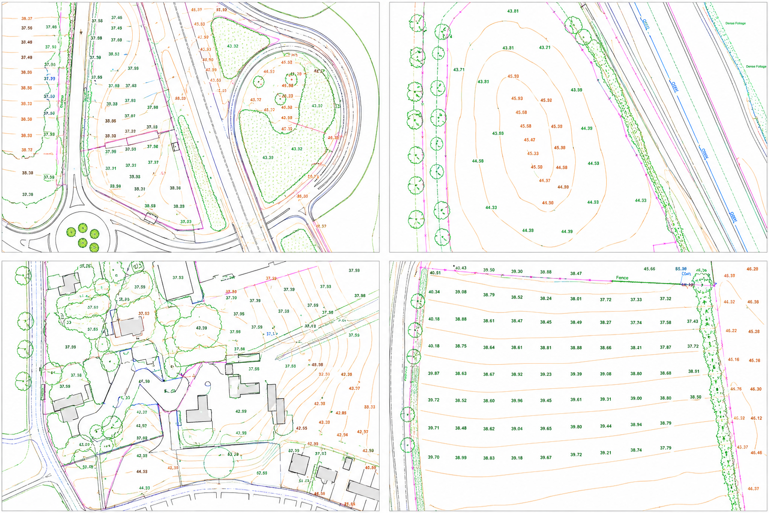 Survey extract — spot levels, 0.5m contours, field drain positions and watercourse detail — 250ha solar farm site, Lincolnshire
Deliverables
Digital Terrain Model (DTM): A 5cm resolution bare-earth DTM across the full 250-hectare site, delivered in ASCII Grid and GeoTIFF formats referenced to OSGB36 / Ordnance Datum (Newlyn). Contours extracted at 0.25m intervals for planning submission and 0.5m intervals for earthworks design. Used directly by the drainage engineer, FRA specialist, structural engineer and earthworks contractor.
Digital Surface Model (DSM): A 5cm DSM capturing all above-ground features including hedgerows, trees, overhead line sag profiles, and existing structures. Used for shadow flicker modelling, line-of-sight assessments and the LVIA photomontage visualisations.
Topographic Survey Plan: Full CAD drawing set at 1:2500 site-wide and 1:500 for the BESS compound and substation areas, showing all surface features: field drains with invert levels, watercourses with bank and bed levels, boundaries, rights of way, access tracks, overhead line positions, and existing structures. Delivered in AutoCAD DWG and PDF.
Orthomosaic: 3cm true-ortho corrected aerial imagery across the full site, delivered as a GeoTIFF. Used as base mapping for the EIA, LVIA, BNG habitat mapping, ALC survey, and land reference plans.
Cross-Sections: Longitudinal and transverse sections through the BESS compound, onsite substation platform, DNO cable route corridor, site access road, and principal watercourses. Delivered in AutoCAD DWG and PDF at 1:500 horizontal / 1:100 vertical.
3D Site Model: A georeferenced 3D mesh model of the full site for use in design visualisation, earthworks simulation and construction programme planning.
Earthworks Volume Analysis: Cut-and-fill volume report derived from the DTM against proposed formation levels across the solar array, BESS compound and access road, enabling the contractor to prepare preliminary earthworks tenders and minimise material import and export during construction.
LiDAR Point Cloud: Classified LAS point cloud delivered for integration into the developer’s GIS and for use by the structural engineer in pile location and obstacle clearance assessments.
Results & Accuracy
Independent check point residuals confirmed a vertical RMSE of ±3.1cm and a horizontal RMSE of ±2.3cm across the site — well within the ±5cm project specification. The combined LiDAR and photogrammetric approach produced a significantly more reliable DTM in hedgerow and boundary zones compared to photogrammetry alone, with the LiDAR vegetation penetration eliminating the elevated false-ground artefacts that would otherwise compromise drainage calculations.
The survey dataset was accepted in full by the Planning Inspectorate as part of the DCO application documentation, by the DNO as supporting data for the grid connection offer, by the IDB in support of the drainage consent, and by Lincolnshire County Council as supporting information for the S278 junction works. The developer subsequently commissioned Angell Surveys to carry out construction monitoring surveys, setting-out control, and as-built verification surveys following approval.
Services Delivered
- Fixed-wing UAV LiDAR survey — 250ha, 25+ returns/m²
- UAV photogrammetric survey — 3cm GSD orthomosaic
- Bare-earth DTM — 5cm resolution, OSGB36 / Ordnance Datum (Newlyn)
- Digital Surface Model (DSM) — 5cm resolution
- Classified LiDAR point cloud (LAS format)
- Topographic CAD survey — all surface features, drains, watercourses, boundaries
- Contour extraction — 0.25m and 0.5m intervals
- Cross-sections — BESS compound, substation, DNO cable route, watercourses
- 3D site mesh model — georeferenced, for earthworks and visualisation
- Cut-and-fill earthworks volume analysis
- GNSS ground control — 24 GCPs, 8 independent check points, NGAN-tied
- DCO, EIA and planning application survey support
- DNO grid connection survey data
- IDB drainage consent survey support
Survey intelligence for modern infrastructure delivery.
Most scoping responses sent within one business day.
RICS-regulated work, led by Philip M. Angell MRICS.