Anglian Water — Lincs & Fens Reservoirs Aerial Survey (LiDAR & Photogrammetry)
Project Brief
Angell Surveys was commissioned by Anglian Water to deliver fixed-wing aerial survey across two of the largest new water resources schemes proposed in the UK in a generation — the Lincolnshire Reservoir, south-east of Sleaford between Grantham and Boston, and the Fens Reservoir in the Cambridgeshire Fens (developed jointly with Cambridge Water). The combined survey envelope covered approximately 70 square kilometres across the two sites, taking in not only the proposed reservoir footprints and their embankment construction corridors but also the surrounding land needed for environmental mitigation, ecological enhancement areas, construction compounds, haul routes and the associated water infrastructure corridors used to transfer raw water to and treated water from each reservoir.
Both reservoirs sit within Anglian Water’s wider Strategic Resource Options programme to secure long-term water supply across the East of England in the face of population growth, climate change and the need to reduce abstraction from over-stressed sources, particularly chalk streams. Each scheme is being progressed as a Nationally Significant Infrastructure Project (NSIP) under the Planning Act 2008, with consent sought through a Development Consent Order (DCO) application made to the Planning Inspectorate. The aerial survey data formed a core supporting dataset across the suite of technical and environmental documents being assembled for each DCO submission, and a continuing reference dataset for the engineering design and consenting workstreams.
The combined survey envelope was unusually demanding in scale and content. It encompassed a varied rural landscape — productive arable farmland on flat fen peat and silt soils in Cambridgeshire, gently undulating clay and limestone agricultural land south of Sleaford, extensive networks of Internal Drainage Board (IDB) drains and ordinary watercourses, designated main rivers, public rights of way, scattered farmsteads and listed buildings, areas of woodland and hedgerow, dismantled rail corridors and existing buried and overhead utility infrastructure. Capturing this varied terrain accurately and consistently across a 70km² envelope with deliverables that would be accepted by the Planning Inspectorate, statutory consultees, engineering designers and environmental specialists alike was the central technical challenge.
Planning & Permitting Context
Both reservoirs are subject to the full NSIP consenting regime under the Planning Act 2008, with a DCO application drawn together from a large suite of statutory environmental, engineering, hydrological and stakeholder documents. The aerial survey was the foundational spatial dataset behind a substantial proportion of those documents:
- Development Consent Order (DCO) — Planning Inspectorate: As reservoirs whose capacity and scale clearly engage the NSIP regime, both schemes require a DCO to be granted by the Secretary of State following examination by the Planning Inspectorate. The orthomosaics, classified point clouds and derived terrain models formed the base mapping for the Book of Reference land plans, the works plans, the access plans and the rights of way plans submitted with each application, and were referenced extensively throughout the Environmental Statement chapters.
- Reservoirs Act 1975 design compliance: Both schemes are designed in accordance with the Reservoirs Act 1975 and the latest national and international guidance for large raised reservoirs, including provision for controlled drawdown in emergency conditions. Accurate, independently checked ground levels across the proposed embankment footprint and the downstream emergency drawdown route were essential inputs to the embankment design, the spillway sizing, the inlet/outlet tower foundations and the safety case documentation that accompanies the design.
- Environmental Impact Assessment (EIA) and Environmental Statement: Each DCO application is accompanied by a full Environmental Statement under the Infrastructure Planning (Environmental Impact Assessment) Regulations 2017. The orthomosaic and terrain data underpinned the landscape and visual impact assessment (LVIA), zone of theoretical visibility analysis, photomontage viewpoint georeferencing, noise propagation modelling, archaeological setting assessment, ecological baseline mapping and the cultural heritage chapter. Survey-grade base mapping at this scale also supports the cumulative effects assessment across the various scheme components.
- Flood Risk Assessment (FRA) and hydraulic modelling: Both sites sit within active surface water and watercourse drainage networks. The reservoirs themselves alter local hydrology fundamentally — raising water against embankments, intercepting field drainage and providing controlled outflows. The DTM derived from the LiDAR survey was used by the project hydraulics team to build the 2D hydraulic models of pre-development and post-development conditions, model the operation of the spillway and emergency drawdown routes, and define flood envelopes for the FRA. At Lincolnshire, the emergency drawdown route into the Helpringham South Beck channel and on to the South Forty Foot Drain was modelled directly from the survey-derived terrain.
- Habitat Regulations Assessment (HRA) and Biodiversity Net Gain (BNG): Both projects engage Habitat Regulations Assessment requirements due to proximity to designated sites, and both must demonstrate a minimum 10% Biodiversity Net Gain in accordance with the Environment Act 2021. The orthomosaic was used as base mapping for habitat baseline survey and the LiDAR point cloud informed canopy height and woodland structure mapping for the BNG metric. Wetland and watercourse margins, hedgerow lengths and tree positions were mapped directly off the survey data.
- Agricultural Land Classification (ALC): Both sites involve extensive areas of agricultural land. ALC survey by the project agronomist required a survey-grade context plan showing field parcel boundaries, drain locations and existing land use. The orthomosaic provided the base for this reporting, supporting Natural England’s review of agricultural land take.
- Internal Drainage Board (IDB) consents: Both reservoir sites lie within IDB administrative areas, with extensive networks of field drains, culverts, outfalls and ordinary watercourses managed by the relevant boards. The aerial survey captured the full surface drainage network with invert levels and connectivity, supporting the IDB consent applications for drainage redesign, culverting and ordinary watercourse modifications.
- Highways consent and Section 278 agreements: Construction of reservoirs of this scale involves significant abnormal load movements, new junction works onto strategic and local highway networks, and temporary diversion of public rights of way. The orthomosaic and topographic survey supported the highways consultation, the Section 278 junction designs, the construction traffic management plans and the temporary footpath diversion applications submitted to the relevant local highway authorities.
- Cultural heritage and archaeology: Both project areas contain known and predicted archaeological assets. The LiDAR-derived bare-earth model is itself a primary archaeological prospection tool — capable of revealing low-relief earthworks, ridge-and-furrow systems, ditched enclosures and other cultural features invisible at ground level. The classified ground-only point cloud was supplied directly to the project archaeology team to support the desk-based assessment, geophysical survey prioritisation and the archaeological setting assessments.
- Associated water infrastructure consenting: Each reservoir is one component of a wider water resources scheme. The supporting infrastructure — raw water transfer pipelines, intake works on contributing rivers, treatment works, treated water transfer mains and pumping stations — extends well beyond the reservoir footprint itself. At Lincolnshire, infrastructure corridors extend between Torksey/West Lindsey to the north, Boston to the east and south-west of Peterborough; at the Fens, comparable corridors connect the contributing river catchments to the reservoir and onward to the existing supply network. The aerial survey envelope was extended to include each of these corridors, providing a single consistent dataset for pipeline route engineering, intake siting, treatment works platform design and the associated planning submissions.
Survey Methodology
A combined area of approximately 70 square kilometres distributed across two geographically separate sites placed firmly outside the realistic operating envelope of multi-rotor UAV survey platforms. Capturing this extent at the accuracy and density required to support a DCO submission — with reliable repeat-survey baseline data — required a fixed-wing UAV carrying integrated LiDAR and metric photogrammetric sensors on a single payload, operating under a CAA Operational Authorisation permitting beyond visual line of sight (BVLOS) flight.
The fixed-wing UAV configuration delivered the survey efficiency necessary for an envelope of this scale: long endurance, high cruise speed and the ability to maintain consistent flight lines across multi-kilometre transects with stable sensor geometry. Each site was flown across a small number of sorties from temporary launch and recovery operating areas close to the survey envelope, with carefully designed flight plans giving full coverage of the reservoir footprint, embankment construction corridor, environmental mitigation areas and associated water infrastructure corridors. Flight line spacing, altitude and overlap were optimised against the combined LiDAR point density and photogrammetric ground sampling distance specifications, balancing sortie duration and battery endurance against achievable accuracy. BVLOS operations were planned and conducted under our CAA Operational Authorisation, with a dedicated Remote Pilot in Command at the ground control station, ground-based observers along the flight envelope and full coordination with relevant airspace stakeholders and local landowners ahead of each flying day.
A single UAV pass therefore captured both datasets concurrently. This avoided the temporal mismatch and seasonal vegetation differences that would arise from separate photogrammetric and LiDAR sorties, ensured precise geometric coregistration of the two products and substantially reduced the operational footprint of the survey compared to crewed-aircraft alternatives. Operating altitudes of approximately 120 metres above ground level provided the optimum LiDAR swath and laser footprint geometry for ground penetration through hedgerow and woodland cover while delivering a sub-5cm ground sampling distance for the photogrammetric component.
For LiDAR, the integrated full-waveform sensor delivered a high single-pass point density across the entire envelope, with first, intermediate and last return classification supporting the production of a reliable bare-earth ground model beneath hedgerow, woodland and scrub. This was particularly important at the Fens site, where field boundaries are typically formed by tall mature hedgerows and small woodland blocks that completely obscure the underlying ground level to photogrammetric capture, and at both sites where mature watercourse vegetation along main drains and ordinary watercourses would otherwise produce a false elevated surface.
Ground control was established across both sites prior to flying. A network of survey-grade GNSS ground control points and independent check points was observed in static dual-frequency mode and tied to the Ordnance Survey National GNSS Network (OS Net), with levels referenced to Ordnance Datum (Newlyn). Ground control was distributed strategically across both reservoir footprints and along the associated water infrastructure corridors at spacings appropriate to the scheme accuracy specification, providing both photogrammetric block control and LiDAR strip adjustment control. An additional set of independent check points — not used in any adjustment — was observed to provide an unbiased final accuracy assessment of the delivered products.
LiDAR processing proceeded through standard strip adjustment, calibration, noise removal and automated ground filtering followed by manual editing of the classified point cloud to deliver a high-quality bare-earth ground class. Above-ground classes were retained for vegetation height and woodland canopy modelling and for archaeological interpretation. The photogrammetric imagery was processed through aerial triangulation, dense image matching and true-ortho correction against the same control network, producing a seamless orthomosaic across the full survey envelope.
Both products were tiled at the delivery stage to keep individual file sizes manageable for downstream users. A 70km² classified point cloud delivered as a single file would be unworkable; instead, the deliverables were tiled on a regular 1km Ordnance Survey grid, allowing engineering, environmental and consenting teams to load only the tiles relevant to the workstream in hand — a critical workflow consideration when the same dataset is being used simultaneously by reservoir designers, pipeline engineers, ecologists, archaeologists, landscape architects, hydraulic modellers and the DCO documentation team.
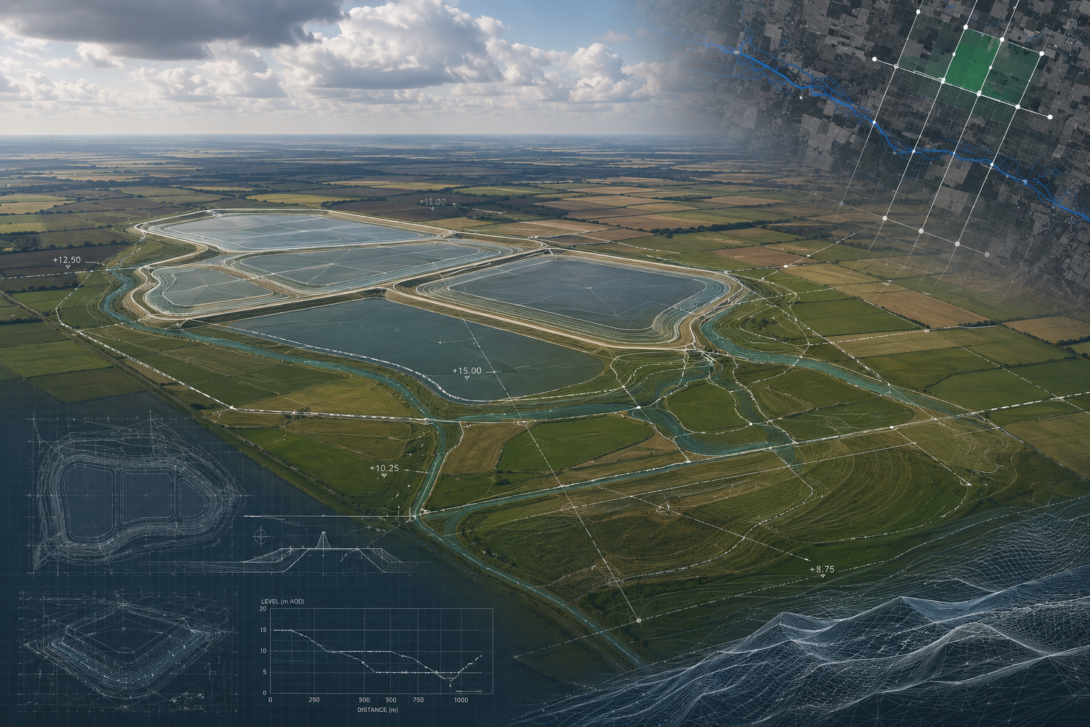
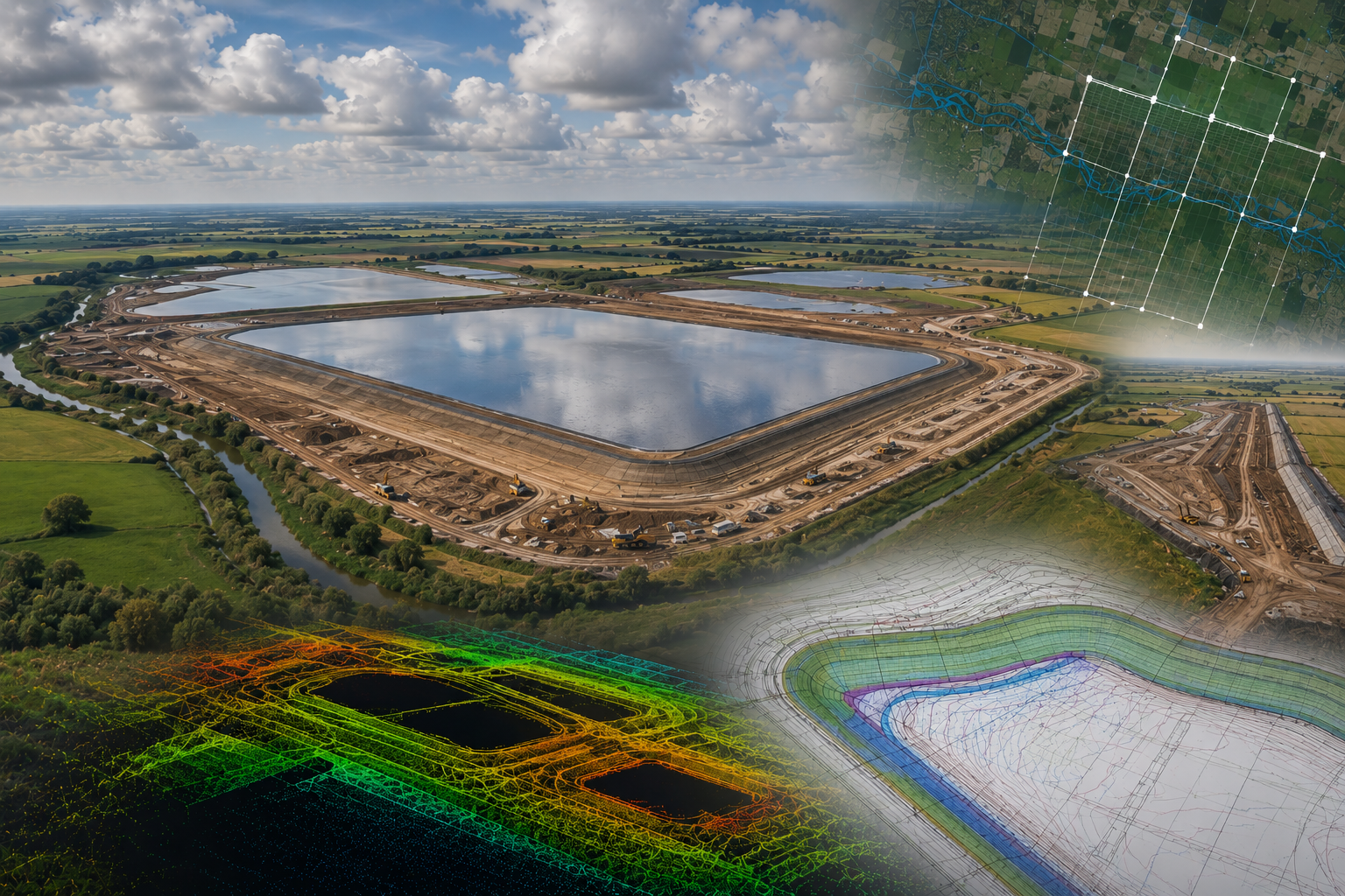 Aerial photogrammetric capture fused with classified LiDAR returns — point cloud rendered by elevation, tile-grid overlay shown across the survey envelope
Deliverables
Tiled classified LiDAR point cloud: A fully classified LAS-format point cloud across the full 70km² combined envelope, tiled on a regular 1km Ordnance Survey grid for both reservoirs. Standard ASPRS classification was applied with ground, low/medium/high vegetation, buildings, water and overhead-line classes separated. Delivered referenced to OSGB36 / Ordnance Datum (Newlyn), with metadata, tile index and accuracy report. Used directly by the reservoir embankment designers, the pipeline route engineers, the hydraulics modellers, the project archaeologists and the LVIA team.
True-ortho corrected orthomosaic: A seamless sub-5cm GSD orthomosaic across each survey envelope, true-ortho corrected against the photogrammetric DSM and tiled to the same 1km grid as the point cloud. Delivered in compressed GeoTIFF with sidecar world files. This formed the base mapping for the DCO application plans, the EIA chapters, the BNG habitat baseline, the ALC survey, archaeological desk-based assessment, public consultation materials, the project interactive maps and a substantial proportion of the engineering design drawings.
Bare-earth Digital Terrain Model (DTM): A regular-grid DTM extracted from the classified ground returns of the LiDAR point cloud, delivered in ASCII Grid and GeoTIFF formats at a resolution appropriate to the engineering design and hydraulic modelling specifications. The DTM was the primary input to the 2D hydraulic models of pre- and post-development hydrology, the reservoir embankment design, the emergency drawdown route assessment, pipeline trench design and earthworks volume estimation across both schemes.
Digital Surface Model (DSM): A regular-grid DSM capturing all above-ground features — vegetation canopies, buildings, structures and overhead line geometry — used for the LVIA, zone of theoretical visibility analysis, photomontage viewpoint preparation, overhead line clearance assessment and the BNG canopy height modelling.
Topographic CAD survey overlays: Surface feature CAD extractions of the principal hydrological, drainage and access features across each site — main rivers, ordinary watercourses, IDB drain network with invert levels, culvert locations, existing access tracks, public rights of way, overhead utility lines, buildings and field boundaries. Delivered in AutoCAD DWG and PDF for incorporation directly into the engineering design and consenting drawing sets.
Vegetation and canopy products: Canopy height model (CHM) derived from the difference between the DSM and the bare-earth DTM, delivered as a regular grid GeoTIFF. Supplied to the BNG ecologists and the LVIA team to support habitat baseline mapping, tree and woodland survey, hedgerow length calculations and visual screening assessments.
Archaeological visualisation products: LiDAR-derived hillshade, slope, openness and local relief model visualisations of the bare-earth ground class, exported as georeferenced raster products. These were delivered directly to the project archaeology team to support desk-based assessment, identification of low-relief archaeological features, prioritisation of geophysical survey areas and the archaeological setting assessment in the Environmental Statement.
Metadata, accuracy report and tile index: A formal accuracy assessment report documenting the ground control network, the residuals at all check points, the photogrammetric block adjustment statistics and the LiDAR strip adjustment statistics. Tile index shapefiles, ISO 19115 metadata records and a delivery readme accompanied the dataset, supporting both onward use and the formal evidence trail required for the DCO submission.
Results & Accuracy
The combined LiDAR and photogrammetric capture across both sites was completed to specification, with independent check point residuals confirming vertical and horizontal accuracy comfortably within the project specification — a critical evidential requirement for survey data underpinning a DCO submission, where the methodology, accuracy and provenance of supporting datasets are subject to formal examination.
The classified bare-earth ground model produced a substantially more reliable terrain dataset across hedgerow, woodland and watercourse vegetation than photogrammetry could have delivered alone. This was essential at the Fens site in particular, where the dense network of mature hedgerow boundaries would have produced an unusably elevated false surface from photogrammetric capture; and at both sites along the IDB drain networks and main river corridors where bank-line vegetation completely obscures the watercourse profile from above.
Tiling the classified point cloud and orthomosaic on a regular 1km Ordnance Survey grid proved decisive for workflow efficiency. With a 70km² envelope being used simultaneously by reservoir engineers, pipeline designers, hydraulic modellers, ecologists, archaeologists, landscape consultants and the DCO documentation team — each working on a different sub-area of the scheme — tile-level extracts allowed each specialist to load and process only the data relevant to their workstream, dramatically reducing data handling overhead and enabling parallel workflow across the consultant teams.
The dataset was accepted in full as supporting information across each reservoir’s DCO documentation and continues to act as the foundational spatial dataset for both schemes as they progress through Examination and into the detailed design, construction and operation phases. The Lincolnshire scheme is progressing toward its phase three public consultation in Autumn 2026 and continued DCO preparation; the Fens scheme completed phase three public consultation in December 2025 and continues to refine its proposals on the basis of consultation feedback and ongoing technical study, all anchored to the same survey base.
Services Delivered
- Fixed-wing UAV LiDAR survey — 70km² combined envelope across two reservoir sites
- Fixed-wing UAV photogrammetry — sub-5cm GSD orthomosaic
- Tiled classified LAS point cloud — 1km OS grid, full ASPRS classification
- True-ortho corrected orthomosaic — tiled GeoTIFF
- Bare-earth Digital Terrain Model (DTM) — OSGB36 / Ordnance Datum (Newlyn)
- Digital Surface Model (DSM) and Canopy Height Model (CHM)
- Topographic CAD survey overlays — drainage, watercourses, rights of way, utilities
- Archaeological visualisation products — hillshade, slope, openness, local relief
- BVLOS fixed-wing flight under CAA Operational Authorisation
- GNSS ground control network — OS Net-tied, independent check points
- DCO application survey support — Lincolnshire Reservoir & Fens Reservoir
- Reservoirs Act 1975 design support — embankment, drawdown route, spillway context
- EIA, FRA, LVIA, BNG, ALC and archaeology base data provision
Survey intelligence for modern infrastructure delivery.
Most scoping responses sent within one business day.
RICS-regulated work, led by Philip M. Angell MRICS.