Highbury Stadium Square Estate — Facade Measured Survey, Islington
Project Brief
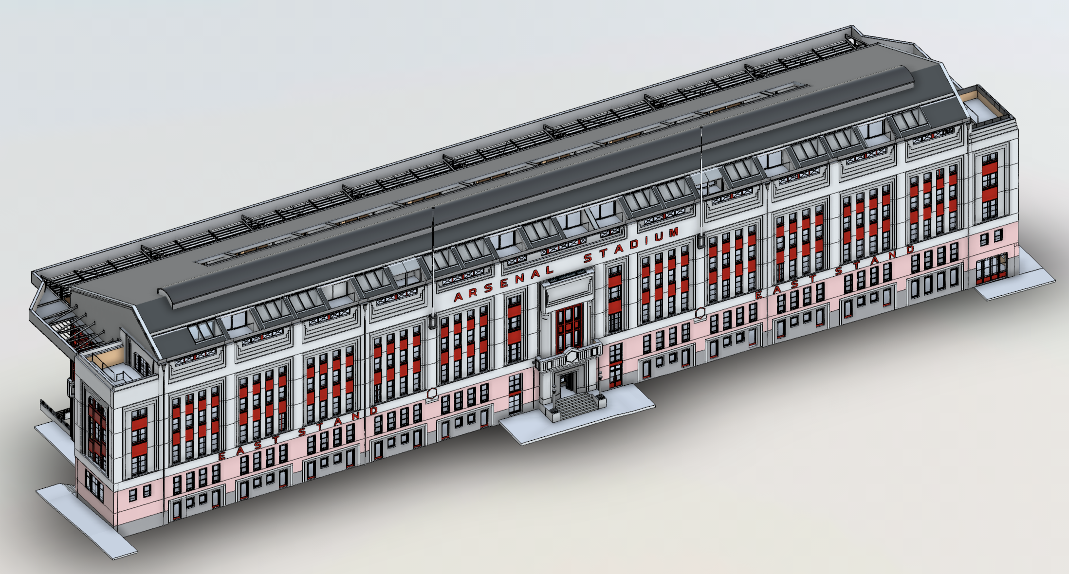
Angell Surveys was appointed to carry out a detailed measured survey of the existing external elevations of the residential buildings forming part of Highbury Stadium Square Estate, Islington, London N5 1FH — the former Arsenal Football Club stadium converted to residential use. The survey was commissioned to support planned facade remediation works across the estate.
The scope covered the South, West and North blocks. The Grade II listed East Stand and basement areas were explicitly excluded from the survey requirement. Penthouse levels on all blocks were included within the survey scope.
The client required two separate deliverables: a full set of 2D AutoCAD DWG drawings and a 3D Revit 2022 model, both georeferenced to Ordnance Survey National Grid with levels related to Ordnance Datum (Newlyn).
Survey Scope
The survey captured all external elevation features relevant to the facade remediation design, including:
- Facade articulations — cornicing, quoins, string courses and projecting features
- All penetrations, outlets, recesses, reveals, soffits and returns
- Windows and doors with full frame, reveal and cill geometry
- Parapets, copings and cills
- Chimneys, fire escapes, balconies, walkways and balustrades
- Roof details and penthouse level features
- External material identification and annotation
All survey control was established on Ordnance Survey National Grid (OSGB36) with spot levels and contour annotations referenced to Ordnance Datum.
Survey Approach
The elevations were captured using reality-capture methods rather than traditional hand measurement, which would have been impractical across an estate of this height and footprint. A georeferenced control network was first established around the blocks on OSGB36, providing the common framework that every subsequent measurement and the final models were tied to.
Terrestrial laser scanning recorded the lower and mid-level facade in dense, millimetre-resolution point clouds, while UAV capture was used to reach the upper storeys, parapets, roof details and penthouse features without scaffolding or rope access. Registering the scan and aerial data into the single control network produced one continuous, fully coordinated point cloud of each elevation. The 2D drawings and the Revit model were then authored directly from that verified point cloud, so both deliverables describe exactly the same as-built geometry.
Site Considerations
Highbury Stadium Square is an occupied residential estate, so capture had to be planned around residents and managed access rather than treating the site as a clear working area. The Grade II listed East Stand was deliberately excluded from the scope, which meant defining clean survey boundaries against an adjacent listed structure. Penthouse levels and high-level detail — normally the most awkward and costly elements of a facade survey to reach safely — were captured from the air, removing the need for access equipment over occupied dwellings.
3D Revit 2022 model — South and West elevation blocks, Highbury Stadium Square Estate
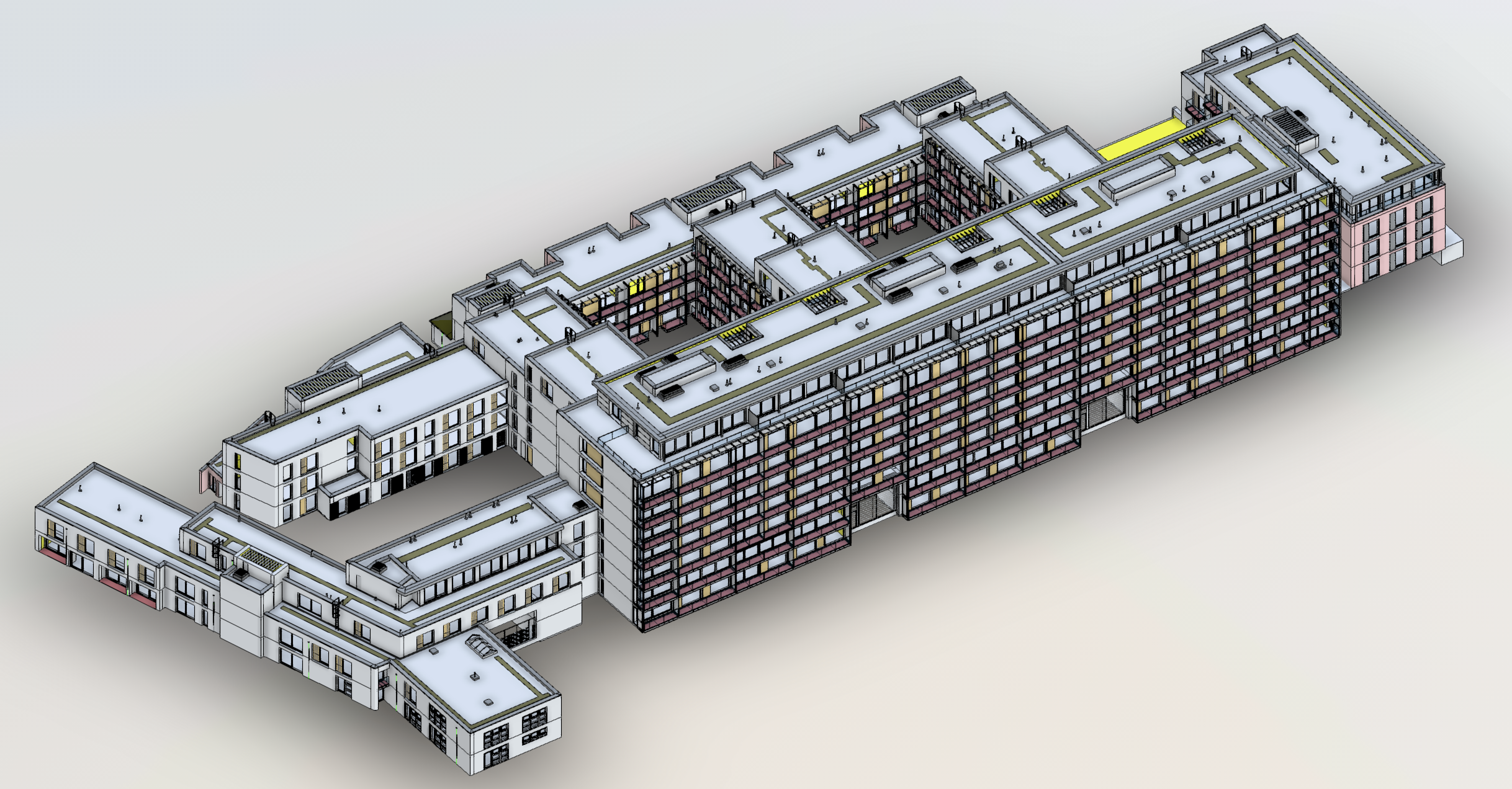 3D Revit 2022 model — detail view showing facade geometry, penetrations and fenestration
Deliverables
Output 1 — 2D AutoCAD DWG: A full set of elevation drawings produced at 1:1 scale in millimetres, with the coordinate origin set at 0,0. Each plan, elevation and section was supplied as a separate DWG file, cross-referenced to the estate block diagram. Spot levels and contour values were supplied as text annotations. All files were purged of redundant layers, blocks and styles. Drawings were delivered in AutoCAD DWG and PDF format.
Output 2 — 3D Revit 2022: A full three-dimensional survey model of the external elevations of the South, West and North blocks, produced in Revit 2022. The model incorporated all facade geometry captured during the survey, georeferenced to the project coordinate system.
Services Delivered
- External elevation measured survey — South, West and North blocks
- OS National Grid control survey with Ordnance Datum levels
- 2D AutoCAD DWG elevations — separate files per elevation, DWG and PDF
- 3D Revit 2022 facade model
- External material schedule and annotation
Outcome
The two deliverables gave the remediation design team a single, coordinated source of truth for the estate’s external fabric. Because the DWG drawings and the Revit model share the same OS National Grid coordinate framework, every elevation, section and modelled element aligns precisely — design packages produced against either output sit in the same space without re-registration. Capturing the facade remotely also kept people away from height and away from occupied dwellings during the survey phase, and left the client with a reusable 3D record of the buildings for any future works.
This project is representative of our wider measured building survey work, where reality capture feeds coordinated CAD and BIM deliverables for refurbishment, remediation and asset-management projects.
Survey intelligence for modern infrastructure delivery.
Most scoping responses sent within one business day.
RICS-regulated work, led by Philip M. Angell MRICS.