Stevin Rock UAE — Multi-Year Aerial Survey Programme Across Ras Al Khaimah Quarries
Project Brief
Between 2017 and 2020, Angell Surveys delivered a multi-year aerial survey programme for Stevin Rock LLC, the Ras Al Khaimah-based quarrying operator. The programme covered all of Stevin Rock’s active extraction sites across the emirate, with a primary focus on the Khor Khwair complex — recognised as the largest limestone quarry in the world by production capacity. Capture data was delivered direct into the operator’s mine scheduling environment in GEOVIA Surpac, providing the existing-ground baseline for pit design, blast planning, bench progress measurement and reserves comparison across each survey cycle.
Stevin Rock has been operating in Ras Al Khaimah since 1975 and runs three principal extraction sites with a combined production capacity of over 80 million tonnes per year of limestone, dolomite and gabbro for construction, cement, steel and mining industries across the Gulf and beyond. The Khor Khwair site alone — including the adjacent sister-company RAK Rock operation — exceeds 60 million tonnes per year at a crushing capacity of around 7,000 tonnes per hour, with known reserves measured in the billions of tonnes. The site benefits from direct adjacency to Saqr Port, one of the largest dry-bulk ports in the Gulf, with crushed-rock product loaded straight from the quarry to ship.
A four-year programme of this scale required a capture methodology that could deliver consistent, repeatable, survey-grade DTMs across pits running to several square kilometres, on a cycle that fitted around active blasting, plant movement and one of the most challenging operating climates in the surveying world.
The Sites
The Stevin Rock estate sits in the Hajar Mountains along the north-eastern coast of the UAE, in the limestone-and-gabbro belt that defines the geology of the Musandam peninsula and northern Ras Al Khaimah. Each pit is cut into the mountain face itself rather than into flat ground, producing steep working faces with multiple bench levels descending several hundred metres from the natural crest down to the operational pit floor.
The principal Khor Khwair complex sits immediately inland of Saqr Port, north of Ras Al Khaimah city. Sister operations and additional Stevin Rock pits are distributed further south along the same mountain corridor — the second of the surveyed quarry sites lies approximately 11 km south of Khor Khwair, in the inland belt closer to the foothill villages. Each site comprises one or more active extraction pits, processing and crushing plant, stockpile yards, haul road networks, water management infrastructure and the connecting access tracks back to the highway and onward to the export port.
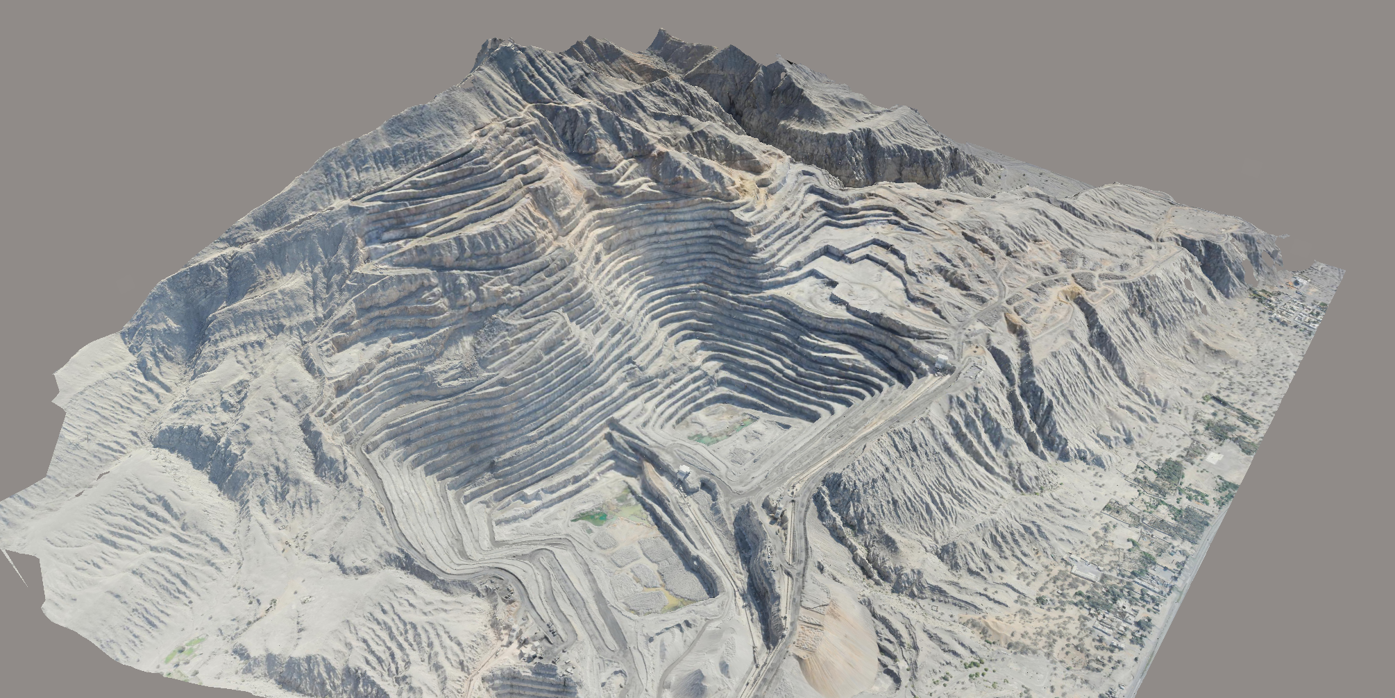
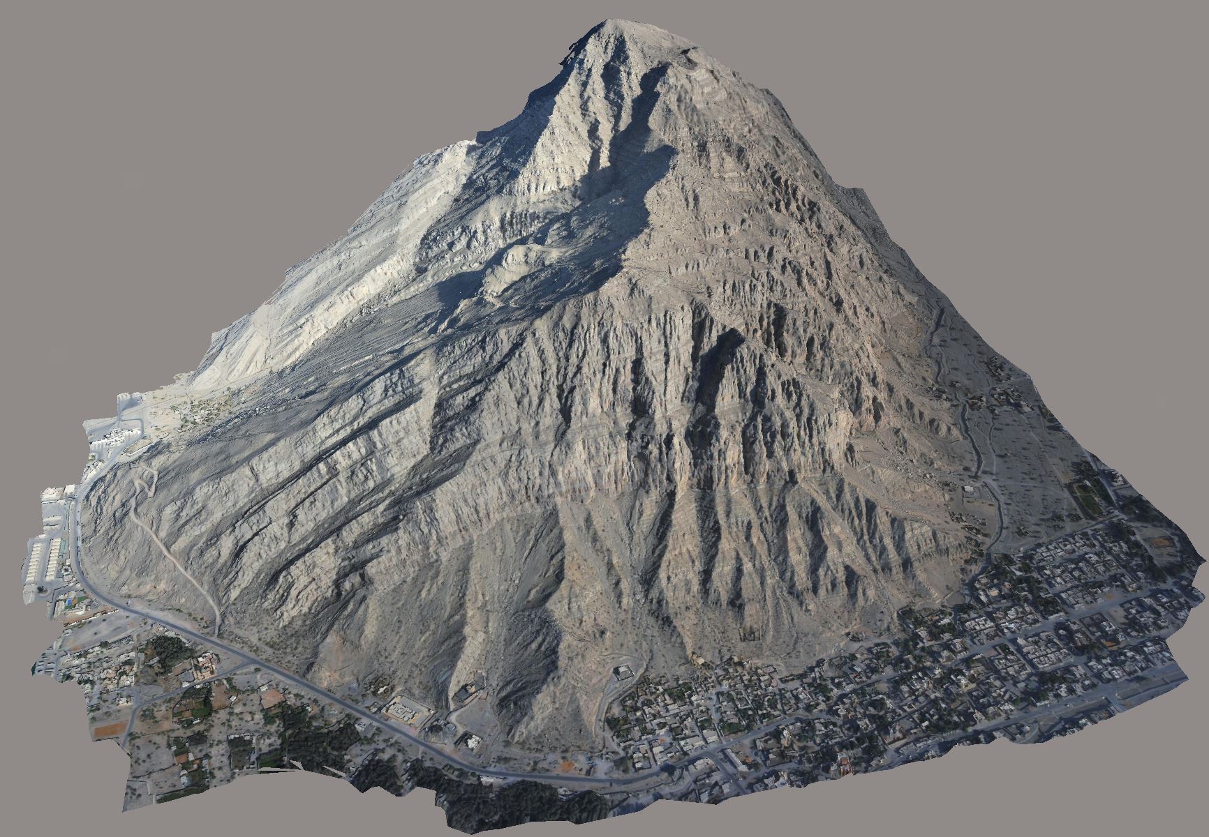 3D reality model of the Khor Khwair limestone mountain, processed from WingtraOne UAV capture flown in 2020. The quarry workings visible to the lower left; the urban edge of Ras Al Khaimah continues to the right. Open the mountain reality model → (Bentley ContextCapture web viewer; pan / zoom / orbit in browser).
Climate & Operating Conditions
Ras Al Khaimah presents a working environment fundamentally different from anything a UK surveying programme has to deal with. Daytime summer temperatures routinely sit between 40 and 48 °C with peaks above 50 °C in shaded conditions; coastal humidity at Khor Khwair runs 60–90 % through the summer months, producing a heat index that closes the working window for outdoor capture to early morning only for several months of the year. Dust from active blasting and crushing, combined with seasonal shamal wind events carrying airborne sand off the Empty Quarter, degrades visibility and contaminates equipment unless protected.
The thermal load on UAV airframes and battery systems is a direct operational constraint — lithium polymer battery performance and electronic temperature limits both shorten substantially in conditions above 40 °C. Survey flights were scheduled into the cooler operational windows (early morning, autumn, winter) wherever the programme cycle allowed, with equipment storage and pre-flight checks adapted to the heat. Camera optics and sensor housings were protected from dust ingress between flights and cleaned to specification before every capture.
The reward for working in those conditions is exceptional light — clear blue skies, low ambient haze in winter, and consistent solar geometry that produces uniform ground exposure across multi-hectare pits with no shadow management required.
Why Fixed-Wing UAV
A fixed-wing platform — specifically the WingtraOne VTOL fixed-wing UAV — was selected at programme mobilisation in 2017 and remained the capture aircraft throughout the four-year contract. The WingtraOne combines vertical take-off and landing with cruise-mode fixed-wing flight, giving the per-flight coverage of a fixed-wing aircraft (multiple square kilometres in a single sortie) without the runway requirement that would have been impossible inside an active pit.
The platform carries a mechanical-shutter full-frame Sony payload, producing the still imagery quality required for survey-grade photogrammetric processing — rolling-shutter sensors are not viable for survey-grade work where pit edges, bench crests and crushing-plant geometry need to be located to documented accuracy. At the pit scales typical of Khor Khwair, a single WingtraOne flight delivers the same data that would otherwise require six to eight multirotor sorties, with consistent altitude and capture geometry across the full pit envelope — critical for reliable surface-to-surface comparison between successive monthly surveys.
VTOL launch and recovery from a small prepared pad inside the operator’s haul-road compound meant no airspace conflict with active plant or the adjacent Saqr Port airspace, and no requirement to clear extraction or crushing operations during the flight window itself.
Survey Control & Capture
Ground control across the Stevin Rock estate was established as a permanent GCP network at programme mobilisation in 2017, with checkerboard targets either painted directly onto stable hard standing or laid down and recovered around the active pits, surveyed by RTK GNSS tied to the local UAE reference frame and re-observed on each capture cycle. Independent check points were maintained at every site to verify per-cycle accuracy independent of the bundle adjustment.
Mission planning was adapted to each pit’s specific geometry. Steep working faces, deep concentric benches and the natural mountain backdrop required altitude profiles that maintained consistent ground sample distance across both the pit floor and the high crest — flat-altitude grid flights of the kind that work on UK earthworks sites were not viable across the 400-metre vertical range from pit floor to natural mountain peak. Cross-strips and oblique passes supplemented the primary grid to ensure full coverage of vertical bench faces.
Photogrammetric Processing
Captured imagery was processed in industry-standard photogrammetric software through a multi-stage pipeline — bundle adjustment with GCP-weighted control, dense matching to a multi-million-point photogrammetric cloud, ground/non-ground classification, DTM and DSM generation, true-ortho production and accuracy reporting against the independent check points. Processing was performed in the UK with secure data transfer between the UAE survey crew and the office workflow; per-cycle deliverables were issued under controlled revision against the established programme datum.
The processing output was a complete pit reality dataset — true-ortho aerial imagery, dense classified point cloud, smooth DTM of the active pit floor and benches, full DSM including plant and stockpile geometry, and a structured 3D mesh of the whole working environment suitable for visual review and stakeholder presentation.
GEOVIA Surpac — Mine Scheduling Integration
The primary downstream consumer of every survey cycle was GEOVIA Surpac, Stevin Rock’s mine scheduling and design environment. Surpac is the industry-standard software for surface mineral extraction operations of this scale, used for pit design, bench planning, blast design, reserves estimation, scheduling and reconciliation against the approved working plan.
Surpac requires the existing-ground surface as a clean, validated, topologically-correct TIN with associated breaklines along bench crests, bench toes, haul road edges and significant change-of-grade features. Raw photogrammetric point clouds — even after ground classification — are not directly usable; they need processing into a Surpac-compatible mesh with the bench geometry preserved as explicit topographic features. Each survey cycle’s deliverable therefore included:
- A surveyed bench-crest-and-toe linework set defining the active pit geometry
- A clean ground-only TIN at metre-grid resolution across the pit floor and bench system
- Contour data at the operator’s specified vertical interval for visual review
- DTM and DSM raster grids in standard interchange formats
- A documented accuracy report against the cycle’s independent check points
That data flowed directly into Stevin Rock’s Surpac project as the existing-ground baseline for the next scheduling cycle — blast designs, monthly extraction tonnage projections, reserves reconciliation against the approved long-term plan, and stockpile inventory checks against the operator’s commercial reporting.
Programme Outcomes
Across four years and multiple pits, the programme delivered to the operator:
- Consistent, repeatable survey-grade pit reality data on a controlled production cycle, independent of the climate-induced limitations on ground-based survey methods
- A documented existing-ground baseline that fed directly into Surpac mine scheduling without intermediate manual handling
- Cycle-to-cycle volumetric comparisons supporting monthly extraction reconciliation against the approved working plan
- A geo-referenced 3D reality model of each surveyed pit and the associated mountain context, used by the operator for stakeholder communication and operational planning
- A safety case improvement against ground-based bench-walking traverse survey, eliminating personnel exposure to the active bench environment and the climate risk during summer operational months
Services Delivered
- Fixed-wing VTOL UAV photogrammetric capture — WingtraOne platform
- Multi-pit programme management across the Stevin Rock estate, Ras Al Khaimah
- Permanent GCP network establishment with cycle-by-cycle re-observation
- Independent check-point verification on every capture
- Bundle-adjusted photogrammetric processing to survey-grade tolerance
- Ground/non-ground classification across active bench geometry
- Bench-crest and toe linework extraction
- Surpac-ready TIN and breakline deliverables for mine scheduling
- True-ortho aerial imagery
- 3D reality mesh of each pit and the wider mountain context
- Volumetric reporting and cycle-to-cycle comparison
- Mobilisation and operation under UAE climate, dust and operational airspace constraints
Stevin Rock and the Khor Khwair complex are the subjects of published industry coverage; the 3D model imagery on this page is from Angell Surveys’ own capture under the 2017–2020 programme. Subsequent monitoring or audit work on the same estate would be commissioned independently and is not covered by this case study.