Kirk Michael Coastal Erosion Monitoring Programme — Isle of Man Government
Project Brief
Angell Surveys was appointed by the Isle of Man Government to deliver a recurring programme of UAS photogrammetric monitoring surveys over the coastal frontage at Kirk Michael, on the island’s exposed north-west coast. The commission ran from 2019 to 2022 and comprised a full photogrammetric baseline followed by repeat monitoring epochs, each one measured, controlled and reported so that successive surveys could be compared directly — with each other, and with the Government’s 2013 aerial LiDAR dataset.
The purpose of the programme was to give the Government a rigorous, repeatable measurement record of an actively eroding soft-cliff frontage: survey-grade evidence on which coastal monitoring and management decisions could be based. The monitoring data, analyses and findings produced under the programme belong to the Isle of Man Government; this case study describes how the measurement programme itself was designed and delivered.
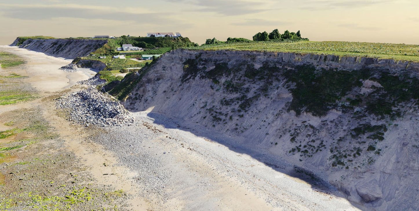
The monitored frontage: soft glacial till cliffs between the beach and cliff-top land at Kirk Michael, captured during survey operations
The Site
Kirk Michael’s coastal frontage is a stretch of soft glacial till cliffs standing between a sand-and-shingle foreshore and the village above. Slopes of this kind respond continuously to marine and weather action, and the management zone — approximately 1,230 metres of coastline — required a monitoring method that could capture the whole cliff system repeatedly: beach levels, cliff face, cliff top and the immediately adjacent land.
The site brings genuinely three-dimensional survey challenges. The cliff face itself is near-vertical in places and constantly changing; the beach below is tidal, with safe working windows dictated by the state of the tide; and the frontage sits directly against a residential village, with public access to the shore at several points. Any monitoring method had to measure the full cliff geometry — not just the plan position of the cliff edge — while operating safely around the public, the tide and the eroding slopes themselves.
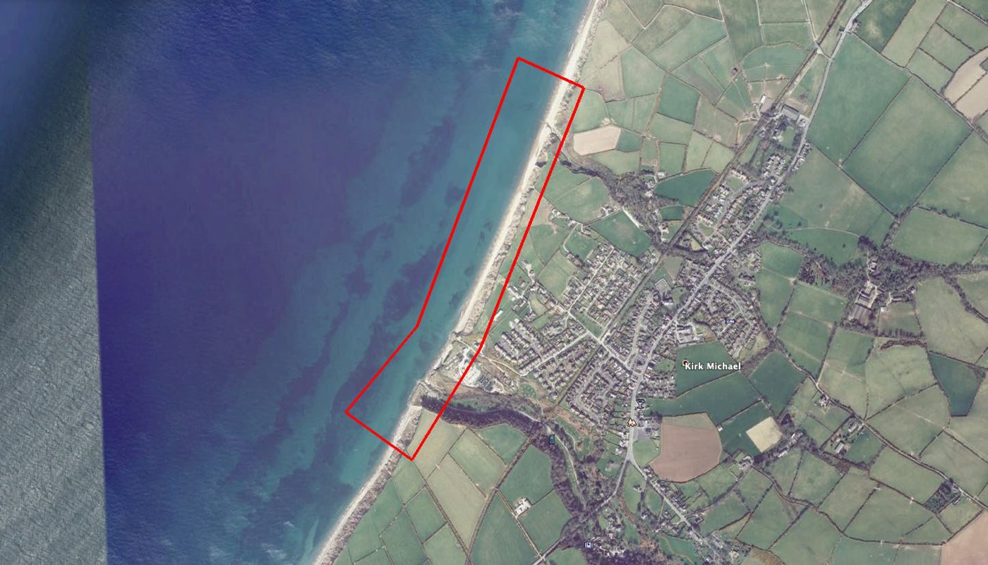 The management zone: the monitored frontage defined over the village and foreshore, flown identically at every epoch
Programme Design
The programme was structured as a photogrammetric baseline followed by recurring monitoring epochs:
| Epoch | Date | Survey |
|---|---|---|
| Baseline | 4–5 November 2019 | Full photogrammetric baseline |
| Monitor 1 | 3 December 2019 | First repeat epoch |
| Monitor 2 | 16 July 2021 | Repeat epoch (2020 epochs prevented by COVID-19 travel restrictions) |
| Monitor 3 | 22 April 2022 | Repeat epoch |
| Monitor 4 | 14 November 2022 | Final epoch of the commission |
Every epoch was flown to the same flight design as the baseline — identical flight polygons, the same 10 mm ground sample distance and the same 70/70 imagery overlap, from approximately 85 m above ground level — so that each successive surface was directly comparable with every previous one. Epochs were scheduled for low water on spring tides to maximise foreshore capture, extending each survey as far seaward as the tide allowed.
Each epoch was also compared against the Government’s 2013 aerial LiDAR dataset, connecting the programme to a measurement record spanning nearly a decade.
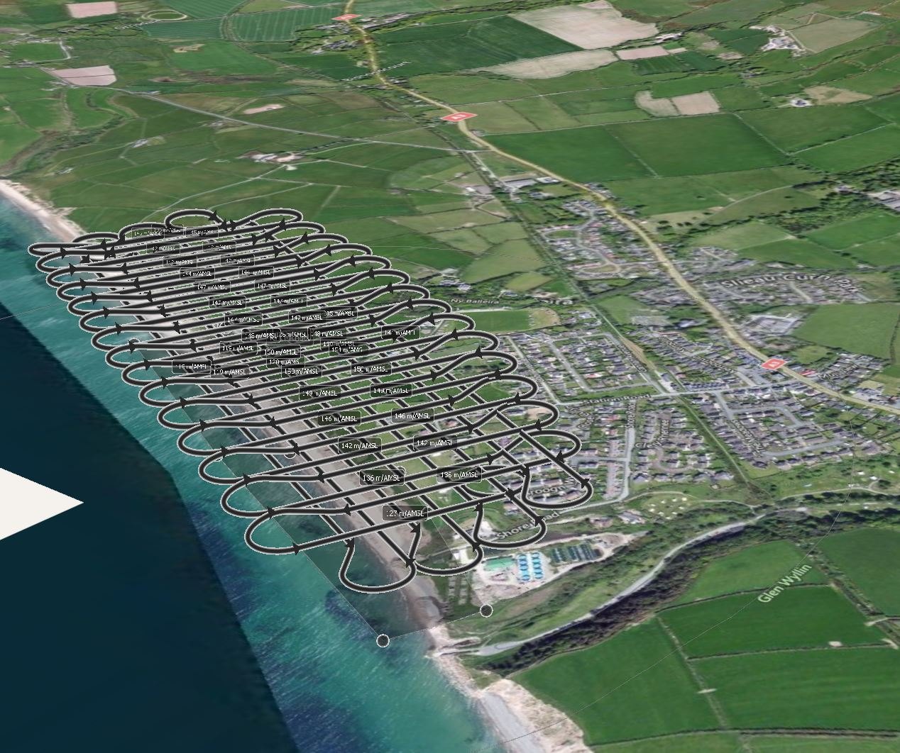 Flight design in three dimensions: the photogrammetric block flown identically at every epoch, following the cliff line between village and sea
Survey Control: The Backbone of Repeatable Monitoring
Change monitoring is only as good as the control beneath it. If the reference framework moves between epochs — or cannot be proven not to have moved — the comparison inherits that uncertainty, and apparent “change” may be nothing more than survey error.
Angell Surveys designed and installed the site’s survey control network at the outset of the programme: semi-permanent control stations at each end of the management zone, supplemented by temporary marks established on the exposed foreshore at low tide (thirteen stations were coordinated in the 2022 epoch). All control was coordinated by GNSS to OSGB 1936, and — critically — the semi-permanent stations were re-validated against their previous coordinates before every epoch. The result is a continuous, auditable control lineage running through the entire programme: every surface, in every epoch, measured on a reference framework whose stability was checked rather than assumed.
Independent Ground Truthing — Every Epoch
Photogrammetric accuracy was never taken on trust. In addition to the control used to orient each survey, every epoch included a fully independent ground-truth survey: GNSS detail points observed across the exposed foreshore and cliff top at low tide, deliberately withheld from the photogrammetric adjustment and used solely as independent check points.
The residuals between each UAS-derived surface and its ground-truth points were tabulated in every survey report against the accuracy band claimed for the deliverables. The Government could therefore see, in every epoch’s report, exactly how well the photogrammetry agreed with independent ground measurement — before any epoch-on-epoch comparison was made.
Flight Operations on a Tidal, Public Foreshore
Flight operations were planned around the practical realities of the site: tide-limited working windows, a public beach and promenade, an eroding cliff line, and the Isle of Man’s own regulatory regime — the island regulates its airspace independently, and UK permissions do not apply.
- Regulatory basis. Operations were flown under Isle of Man Civil Aviation Administration permissions held by Angell Surveys for the programme — most recently Permission 2022/054, which included night provisions and airport-zone provisions with coordination through Ronaldsway Air Traffic Control.
- Take-off and landing. An established arrangement with Michael United AFC provided a controlled take-off and landing site adjacent to the survey area throughout the programme, with letters of introduction carried on site.
- Tide and public management. Each epoch was flown to a tide plan, with foreshore working confined to briefed windows, and take-off, landing and ground survey managed around public use of the beach and shore access points.
Processing and Quality Assurance
Each epoch was processed through an independent dual-package photogrammetric workflow — the primary photogrammetric adjustment and surface generation verified in a second, independent software package — so that no epoch’s surface depended on a single processing chain. Ground-truth residual reporting then closed the loop between processing and independent field measurement.
Cross sections were cut at 50-metre intervals along the frontage with successive epochs overlaid on the same section lines, and DTM-difference (isopachyte) analyses were computed between epochs and against the 2013 LiDAR baseline, expressing surface change across the whole management zone rather than only at sampled lines.
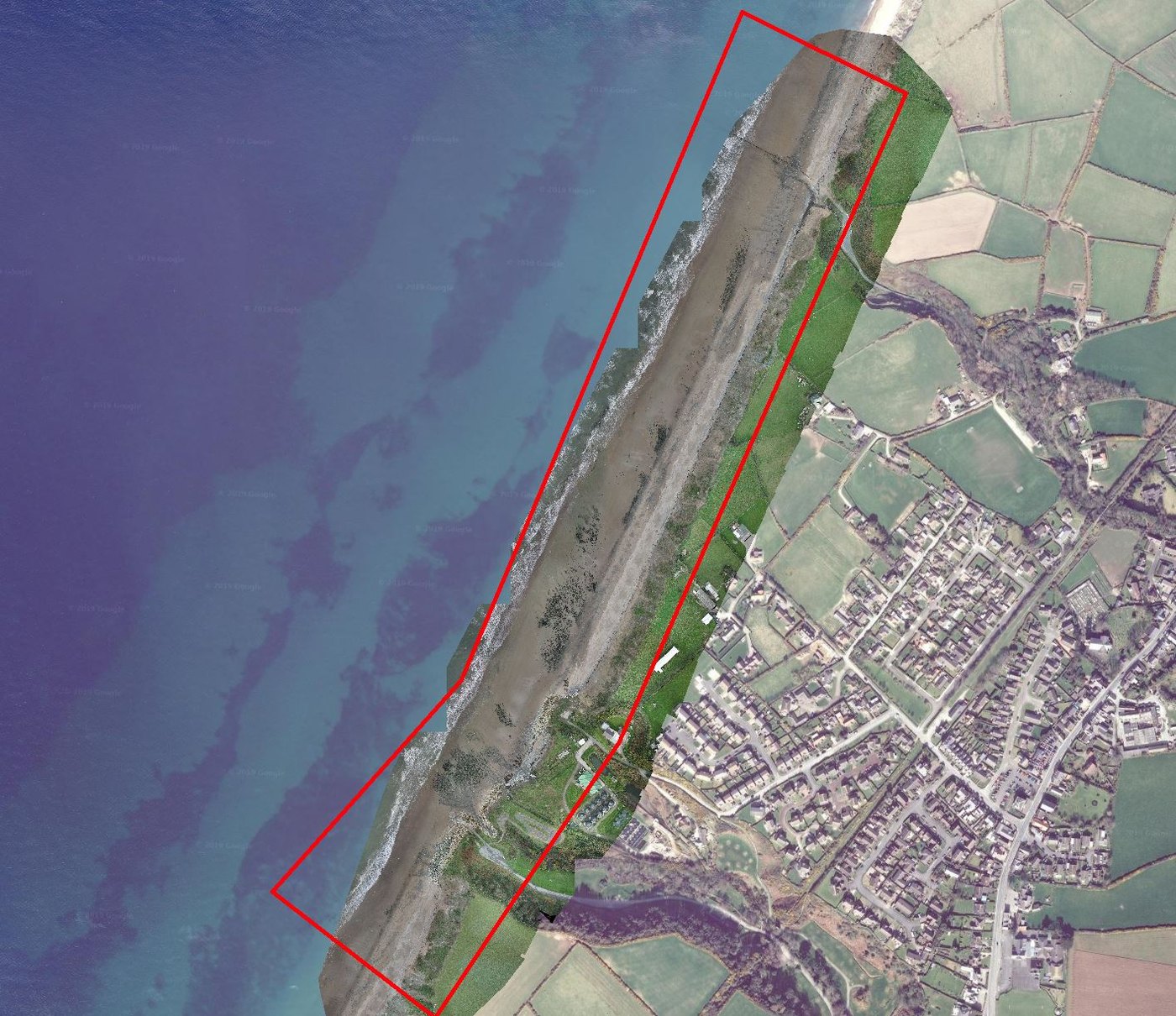 10 mm ground-sample-distance orthophotography, produced at every epoch across the full management zone
Deliverables
Each epoch was delivered as a complete, self-contained survey package on the OSGB National Grid:
- Classified photogrammetric point clouds
- Digital Surface Models and Digital Terrain Models
- 10 mm ground-sample-distance orthophotography
- Contours, cliff-top and cliff-toe lines
- Cross sections at 50 m intervals with successive epochs overlaid
- DTM-difference (isopachyte) and volumetric change analyses between epochs and against the 2013 LiDAR baseline
- A full monitoring report per epoch, including control validation and ground-truth residual tables
- Google Earth tile sets for non-specialist users across Government
To support wider stakeholder communication, a browser-based 3D reality model of the July 2021 survey was published, allowing non-technical audiences to explore the frontage without specialist software.
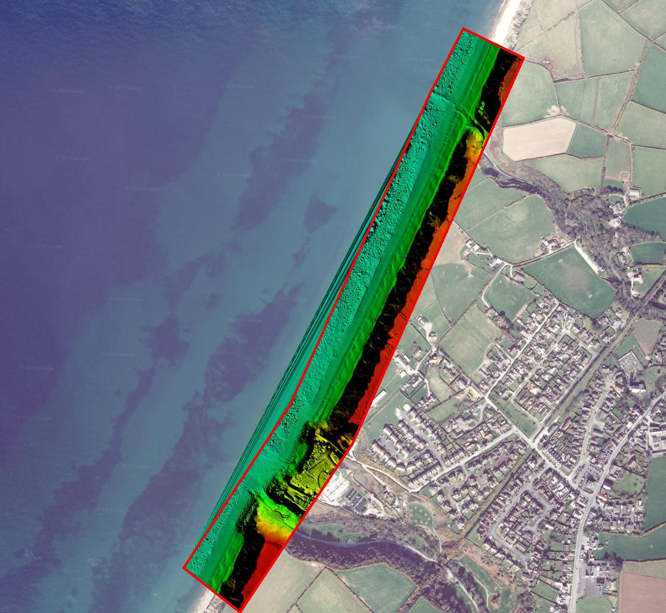 Epoch Digital Terrain Model across the management zone — the repeatable measurement surface behind the programme’s change analyses
Programme Outcome
Over three years and five epochs, the programme gave the Isle of Man Government a consistent, quality-assured measurement record of the Kirk Michael frontage — every surface flown to the same design, controlled on the same validated framework, independently ground-truthed, and reported in a form that supports direct comparison across a near-decade of data when combined with the 2013 LiDAR baseline.
The analyses, findings and conclusions drawn from that record are the Government’s. What the programme demonstrates is the discipline that credible coastal change monitoring requires: permanent control with a proven lineage, independent ground truth in every epoch, identical flight and processing design throughout, and reporting that shows its accuracy evidence rather than asserting it.
All survey data was transferred to the Isle of Man Government on completion of the commission.
Related services
This programme draws on our UAV photogrammetry, topographic survey and aerial survey services.
Survey intelligence for modern infrastructure delivery.
Most scoping responses sent within one business day.
RICS-regulated work, led by Philip M. Angell MRICS.